Monday, May 31, 2010

trip # 6 Overnight stay on the Wreck Island, Sunday May 30 - Monday May 31, 2010

My goal was as always - to reach the destination not reached previous time. Now it was Wreck Island in Massasauga Provincial Park (see trip #5 and the map with campsite descriptions). I decided to go overnight on Sunday to Monday to avoid the weekend traffic on 400 and to have a better choice of campsites.
Knowing that I'm not obliged to drive back tonight I was more relaxed when packing in the morning and left at 8:05 instead of 7:00. Highway 400 Northbound was not crowded and it takes me less than 2 hours to come to Pete's place Access Point in Massasauga Provincial Park.
The full time schedule of this trip is presented at the Russian version of this site.
The office was closed and I began the self-registration procedure. When I was almost ready, the officer came in and we switched to the regular procedure which I like more. Especially because we could discuss sites advantages and weather (wind first of all) forecast. As a result I choose site 336 on the Sharpe Island with the opportunity to switch to # 325 on Wreck Island if such will be my desire and it will be unoccupied. I paid $11.00 in cash (1 night for 1 person), received green sheet for the car parking and pink one for site occupation and dove to the launch point.
It takes me another 30 min to inflate the kayak and put everything inside.


11:05 AM I started setting my course to the first strait connecting Blackstone Harbor to the Woods Bay. In less than 20 min I was there and crossed the Woods Bay to the Captain Allen Strait.
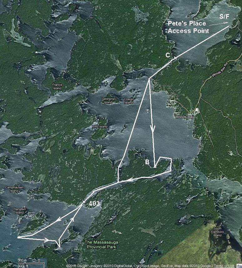
(See map of the trip #5).
At 12:00 I made a stop at the site # 304 on the North bank of the Captain Allen Strait not far from where it flows into the Moon Bay (it's the point where map begins).
12:20 PM I headed toward the Sharpe Island. On my left were long island where we turned back last time with Ivan and then horseshoe shaped Pleasant Island.
#325 site inlet on the Wreck Island.Rocks are really impressive!

Inland part of inlet and fireplace at #325.

My tent on the smaller spot but closer to the fireplace.

Just before departure from Wreck Island.

Fantastic beach on the Northwest shore of the Sharpe Island.

Launch site at Pete's Place Access Point. My gear and my kayak.

End of trip.

Tuesday, May 25, 2010

trip # 5: First try of Georgian Bay, May 24, 2010

I've two choices for this long first summer weekend: Long Lake in Kawarthas or any place of my choice on Georgian Bay. Have to say that I never been to Georgian Bay kayaking though heard a lot about how fantastic it is. We were going duo: me and Ivan. Fishing which is very important for Ivan could be better in Kawarthas but the huge concentration of blood-sucking insects too. As to the Georgian Bay I have no special point chosen and weather (wind) conditions are more important there. So may be it was meteorologists who made final decision. They promised 27 C and almost no wind - ideal conditions for the Georgian Bay first trip. Then I spent a day reading the books and looking on the maps to find an optimal destination for the one day trip. It has to be closer to Toronto than Parry Sound and paddling distance no more than 20 km. Massasauga Provincial Park seems to meet all these requirements.
Again the first trip to new place turned out to be half as long as was planned initially (see map). We were lucky this morning driving on almost empty hwy 400 to the North. In two hours we were at the South Access Point (Pete's Place) to the Massasauga Provincial Park. (Exit 189 from hwy 400 to 69 (3.5 km), then Left to High Street (6,5 km) and then 17 km on the Healey Lake Road and 600 m right to the Pete's Place).
They confirmed that they provide parking only for their campers - others have to go to the various Woods Bay marinas. However when I bought the Park Map ($10:00) at the office they decided that it's enough to provide parking for us.
At 10:05 we put the paddles into water. Leaving the home at 7:35 it was great result!


45 minutes more and we are at the first strait connecting Blackstone Harbour to the Woods Bay.


Entering Woods Bay from East.


First short halt on the Southwest shore of the Woods Bay.

The geese took a rest too. At the farthermost point of our trip. From here we turned back.See map.

Nice beach at the site 403 on the strait between Woods Bay and Moon Bay. We swam here, had a lunch (misu-soup, sandwiches and vegetables) and relaxed before paddling back home.
We were back to the Pete's Place Access Point at 4:30 PM and at 5:00 PM started the car.
This time traffic was heavier than in the morning because it was the end of the long weekend. In spite of this in 2.5 hours we were at home.  Our first reconnaissance trip to Georgian Bay was fulfilled successfully.


Thursday, May 20, 2010

trip #4: South Muskoka River - there and back or down and up - May 17, 2010

As it is well described in Kevin Callan's "Ontario's Cottage Country" and in Hap Wilson's "Canoeing and Hiking Wild Muskoka",  navigation on South Muskoka River down from Baysville (hwy 117 East of 11) is possible to hwy 11 and comprises about 42 km. However due to absence of public campsites further than on Cooks Falls (about 8 km down from Baysville) recommended route includes way down to the Cooks Falls and way back (upstream) to Baysville. As Kevin explaines it gives you a better understanding how the explorers and fur traders felt like travelling this route in both directions. This time my understanding became even "more better" due to earlier than usually beginning of black fly and mosquito season.
On the river everything depends on the water level. This time it was "medium" I think. Yes, it was spring but after such a snow-less winter no flood can be observed. And at any rate I'd like to come here in the midsummer. Even my inflatable kayak had to be lined or lifted over in too many shallow places. I think the current was stronger now than it will be in summer. As a result I lined the kayak in two places when going upstream, in sum it was may be about 1 km  to splash through the cold water on slippery stones. Well enough that I have my beach-shoes with me and it was not so painful to step on the stones. In any case it was much better than on the portages, where both my hands were busy with the kayak and black flies and mosquitoes sting me cruelly.
And despite all this I had a wonderful time on Muskoka!

Launch site in Baysville at the small park on the West bank below the dam. Everything is ready to go.
Downstream the South Muskoka River


Fairy Falls about 2.5-3.0 km from the Starting Point in Baysville. Easy portage 155 m on the left bank.


Approaching the rapids before the Thompson's Folly. On my way back I was forced to line my kayak upstream here for about 1 km.


My kayak already below the Thompson's Folly. I simply pulled it over the rock on the left. 


Cooks Falls - the last I reached this time and the only one could try to go through on the kayak. I didn't try because didn't like to portage kayak back through the infuriate clouds of black flies and mosquitoes already biting me thoroughly.


Nice open spit upstream of a rapid - the only place I could rest a bit without be biting by the insects.


Typical Muskoka view, though the chairs are not 100% Muskokan.


Back to the dam and Start Point in Baysville after 5 hours paddling.


"Me and cucamber" - a self-made picture at the parking lot in Baysville. Finally I can eat a little bit without insect intervention.
Two more hours on the highways 117, 11 and 400 and I was at home!

Wednesday, May 5, 2010

trip #3: Indian River from Warsaw to Warsaw Caves and Back - May 4, 2010

Tuesday May 4, 2010

From the beginning it was presumed to be a short leisure trip to relax a little bit and to test the new Advanced Elements Kayak Sail. This route was also chosen because of short and well known driving distance from Toronto (Richmond Hill): Bloomington Rd (hwy 47) and 7A to Port-Perry,  7A and 115 to Peterborough and then 7, 28 and 4 to Warsaw, ON (about 165 km = 2 hours).

Public Launch beside the church in Warsaw was empty and Indian River water surface quiet and friendly. As was mentioned in every description of this route I've read before the main problem was the depth - amount of water in the River. Though this winter was poor on snow the spring is the spring and water at least covered numerous old stumps seen under water.


Further up stream (nominally because one cannot notice any stream at all) the river became even deeper, though almost everywhere you could find dead trees under water. After less than 1.5 hours of unhurried paddling we crossed the scenic cliffs and marshes and came to rest upon what had to be the Park launch site. At the same time it was a natural end of a trip, because the river here divided into three or more shallow stony channels somehow disappearing among marshes and bushes.


After light lunch we install our new AE Rapid Up Sail and  set out  for return. We even were lucky to catch the fair-wind for some time and made a short video of us sailing. Unfortunately the wind changed soon to the opposite direction and the rest of the route we paddled hard against the wind.


It was still mid of the day when we reached our starting point in Warsaw, deflated kayak and headed back home. I'm not sure I'll come there once more. Somebody mentioned this route as a good one for the family with children, but I we didn't see any attractive campsites there.May be in summer when water level will be much lower there will be some but the navigation in the shallow water will be minus.


First sea trial of the new Advanced Element Rapid Up Kayak Sail.

Monday, April 26, 2010

Trip #2: The Bottle (Lake) uncorked! - April 24, 2010

Saturday, April 24, 2010
Three weeks after first trip the weather became favorable again and I decided to fulfill uncompleted route to the Bottle and Sucker Lakes. This time all the maps were in my pocket, GPS was tuned to the shortest way from home to the bridge at Catchacoma Lake, the car was loaded from the night and it seems nothing could prevent me to have a great journey.
At 8:10 AM I left my home heading to 404, 48, 12 and...surprise-surprise: When I turned right from 12 to Regional Road 15 I saw a big sign "ROAD CLOSED". As a doubting Thomas I drove 2-3 km on the empty road until came to rest against real road closure with the fence closed and bridge fully destroyed. No way.
I consulted my road map and GPS and decided to make a detour to the North. I followed 12 to 48 on East (near Talbot river, where a year ago we tested our kayak for the first time), then 48 to 46 South and then  back to Regional 15 (aka hwy 8) which brought me to the Fenelon Falls and further to hwy 36, 507 North and finally to Beaver Lake Road East where in 4 km the public launch site was near the bridge.  It was 11:00 AM. In 30 min I was into my Inflatable Advanced Frame Convertible Solo Version and ready to go.


This time I follow strictly right bank of the South East Inlet of the Catchacoma Lake to come to the Bottle Creek Inlet by the shortest way.


 And indeed it took me 35 min to come to the dam on the Bottle Creek. It was the first short portage (about 40 m on the rolled rocks along the East side of the Creek ). It was the place where from we turned back last time. Now I spent less than half an hour to move kayak and gear on the other side of the dam (about 1-2 m up the stream). Ahead of me was almost straight water lane 20-50 m wide and about 3 km long - Bottle Creak - leading me Eastward to the Bottle Lake.


Campsite on the left (North) bank of the Bottle Creek near it's mouth at the Bottle Lake

On the Bottle Lake at the portage to the Sucker Lake (160 m).


View on the portage from the kayak above.


View on the portage from the Sucker Lake.


Day campsite on the right (South) bank of the Bottle Creek at it's mouth on the Bottle lake


.

Cottage under construction on the way back when approaching the bridge on the Beaver lake road

Monday, April 12, 2010

trip # 1 The 2010 season is open! The Ice Cork in the Bottle (Lake) - April 3, 2010

Hello to everybody and happy beginning of the kayak/canoe season!

It was due to unbelievably warm weather this spring that we could  "to put to sea" on April 3. Believe it or not it was 25°C in the air and 0°C into water (ice was still present in many places on the water surface).

Our goal was the Bottle Lake in Kawartha Highland Park. Besides the intriguing name and our desire to visit new place the permission to fish for lake trout in Sucker Lake which is within a short portage (~ 160 m) from the Bottle Lake was the main attraction for us.


As a starting point we choose the bridge on the Beaver Lake Road at the South end of the Catchecoma Lake. Our GPS gave us 165 km long route from our house in Richmond Hill (Oak Ridges to be more precise) to this bridge. But not to drive the unknown roads in the morning we followed our usual route to the Crab Lake (near Apsley, North of Bourleigh Falls). The only difference was that just after Bourleigh Falls we turned west onto hwy 36, then North onto hwy 507 and East onto the Beaver Lake road to the bridge. It takes us about 2.5 hours to drive there.


Parking space near the water on the South-West side of the road/bridge was empty. We were surprised by its small size and how full will it be in the summer time. But now we were alone and it takes us no more than 15 minutes to inflate our kayak and set out. We headed directly under the bridge when heard a voice from above: There're no water there, guys! A man on the bridge smiled to us and pointed with his hand somewhere on the other side of the bridge. Of course we decided that he's joking  and came under the bridge and further into the one of the bays of the Cathecoma Lake. Only half an hour later, when we came to rest against huge field of black ice almost invisible from afar did we understand what the man on the bridge had in mind. Now we noticed this: part of the water mirror was exactly as mirror has to be - flat and black - as if no wind waved to disturb the surface. At the same time there was a wind and in many places we can see "normal" alive water wrinkled by the wind. Yes, there was still an ice covering part of the lake and we were not a icebreaker, but poor inflatable kayak and we had to be as twice careful to avoid direct contact with the sharp block of ice. It was in part due to this unexpected obstacle that we lost orientation and made a big loop around the lake before to come back to the West shore where the Bottle Creek had to spring from the lake to the West.

Tuesday, September 22, 2009