It is not the first time
when I followed canoe route described by Kevin Callan. This time our
destination was the remote
Island Lake in
Southern Ontario
 |
| Map 1. Our route to the Wahwashkesh Lake. |
We started from my house in Caledon
at 7:30 AM and entered hwy 400 from hwy 9 {Map 1) After almost 200 km on hwy 400 we
exited East to hwy 124 (exit 231) just past Perry Sound. Driving North on hwy 124 we passed Danchurch and then turned left onto hwy 520 North. After a while hwy 520 actually went West and at some point we turned right (North) onto Wahwashkesh Rd which ends at Wahwashkesh Lodge and Marina {Map 2}.
 |
| Map 2. Indian Narrows Rd from WWK Lake Marina on the right to the launching place on the left. |
After a brief conversation with local people at Marina we learned that there is enough water in the Farm Creek and that Indian Narrows launching place and parking lot are little bit further by the Indian Narrows Rd (Map 2).
At 10:30 AM (exactly 3 hrs driving) we were at the parking lot on the shore of Wahwashkesh (WWK) Lake. It was Thursday morning and parking lot was practically empty. On the shore a few local people reloaded beer boxes from the car to the boat apparently preparing to the coming weekend. They confirmed that there is plenty of water in the Farm Creek and that "this boat" (our inflatable kayak) will go through in any case. The owner of a cottage situated just in front of the launching place kindly explained us how to leave the Bay we are in and how to reach the Farm Creek inflow on the Northern side of WWK Lake.
Encouraged by this information we loaded our gear onto kayak and prepared to go. One lady was so kind to take a picture of us (Pic.1).
 |
| Pic.1. Bohdan and I ready to go. |
It was 11:40 when we put our paddles into waters of WWK Lake. There were almost no wind and it took us less than one hour to reach the place we believed to be the very NW corner of the WWK Lake, where Farm Creek flows into it. Alas! It was not! There were no traces of two small islands which had to be there. Finally I did what had to be done much earkier - checked our position with the GPS on my cell phone. Yes, we made a mistake which Kevin Callan mentioned in his book " Top 50 Canoe Routes of Ontario": "Wahwashkesh Lake is a large piece of water to paddle across , with a good number of islands to confuse a navigator along the way." ... We turned West too early and went deep into big Tracy Bay of WWK Lake. (Map 3).
 |
| Map 3. Our route on the WWK Lake to the Farm Creek. |
It costed us extra 3-4 km paddling and almost 1 hour of lost time. Fortunately next "corner" was a real one with two small islands, one of which was Isaak's Island and just behind it was Farm Creek inflow. We were there at 2:00 PM.(Pic 2)
 |
| Pic.2. At the beginning of a first portage. |
Map 4 presents our route on the Farm Creek from WWK Lake to the Island Lake and indicates places where pictures were taken.
 |
| Map 4. Farm Creek route. |
Because the Farm Creek fell down to the WWK Lake as a small stream on the steep rocks one had to portage kayak and gear along the Creek to a small pond (Pic.3).
 |
| Pic. 3. Small pond at the end of the first portage. Just in the forest on the background the second portage began. |
This first portage was about 100 m long and not difficult. What was really tiresome that after you crossed this small pond (~ 200 m) there was another 100 m portage which began in a very muddy place.
 |
| Pic.4. Bohdan at the end of second portage. |
 |
| Pic.5. Up the Creek after second portage. |
After this second portage we navigated Creek for about 1 km and at the Northern end of another elongated pond one can see a hunter's cabin. (Pic.6). However it's not easy because cabin is not on the open shore but is hidden by the pine trees. Anyway moving slowly along the right (North-East) shore of the pond one finally will see either cabin or launching place where the third portage begins (Pic.7).
 |
| Pic.6. Hunter's cabin. |
 |
| Pic. 7. At the launching place near the cabin. Behind me the pond we just crossed. |
A very good trail ( ~250 m) leaded us past the cabin and to the Creek again where a steep rock went to the water. After this third portage Creek was winding between grass banks with the general direction to the North (~1 km) and then toward N-NW one more km. Somewhere here we met the first beaver dam. It was pretty tall - about 4-5 feet and all around it was very muddy. Hear we felt one (only one!) disadvantage of our inflatable kayak comparing to hard-shell canoe: one cannot simply pull it over the dam because every sharp-cut branch on the dam could make a hole in the kayak. (And one we did at the bow, though not very serious of a hole fortunately.
 |
| Pic. 8. Beaver dam. |
 |
| Pic.9. Muddy damned dam. |
 |
| Pic.10. Typical view of the Farm Creek above the beaver dam. |
At some point one have to turn left on 90 degree or even more ignoring open water on the right side which is where Cramadog Creek flows into Farm Creek from the East. We were so concentrated onto finding the right way and place to turn that didn't notice the big sign on the rock at the right bank indicating direction to the Farm Creek. We discovered this sign on our way back and took a picture of it (Pic.11).
 |
Pic.11. Sign erected on the right bank of the Farm Creek at the inflow of Carmadon Creek
showing direction to follow on the farm Creek. |
Anyway we turned in a right place and began meandering with the Creek moving in general W-NW direction though meandering was so strong that sometimes we simply did circles on the water.(Pic.12). Plus to this we met the second tall beaver dam besides a few low which we successfully lifted over.
 |
| Pic.12. Farm Creek near the place of a "Big Bend" (after it) where the Cromadon Creek came in from the West (from the left on this picture). On the right side of the picture the sign is seen. |
Thus meandering a lot Creek went West and we waited patiently when it finally turned to the North as was shown on our maps. In the meantime we had one more small portage over the big rock (may be 10 meter long) (Pic.13).
 |
| Pic.13. Short portage over the rock. |
Finally Creek and we turned right, but our worry still grew up because the forest around us came closer and it seemed that there were no exit for the Creek at this place.Plus to this Creek itself became very narrow and almost lost in the marshes. Evening came closer and we were almost ready to stop for the night where we were, when suddenly one of us exclaimed loudly: "Bridge!". It sounded like when sailors of old times first see the land after many days in the open ocean. Yes, we finally reach the snowmobile bridge (Pic.14) shown on our maps. Just at this bridge the fourth and last portage began. Expedition was alive!
 |
| Pic.14. Snowmobile bridge as it viewed from the Creek. |
 |
| Pic.15. Bridge and beginning of the fourth portage (on the left). |
This longest portage (~350 m) was really long, but the feeling that we were not lost and that Island Lake was just "around the corner" gave us additional power.
 |
| Pic 16. Part of the portage was in the tall grass. |
The last portage was done and finally we put our kayak into the waters of Island Lake. It was around 8:00 PM, thus it took us about 6 hrs to navigate the Farm Creek. Little bit too long comparing to others 5-4.5 hrs but we never been in a ruch, relaxed and took our time and a lot of pictures. Plus to cross beaver dams we with our inflatable kayak we had to unload everything, lifted it over the dam and then put everything back which was longer procedure than simply pull canoe over the dam.
Having not so much light time before us we decided to follow the nice description/recommendation from
"Gone Canoeing!" site and stopped on the South side of the Fire Island (they named it Blueberry Island). It's really very nice spot with the stone fire ring, improvised table and handsaw hanging on the pine tree nearby.
 |
| Pic 17. View from Fire Island onto the South part of the Island Lake, where the Farm Creek flashes out of Lake. |
 |
| Pic. 18. Campsite on the South end of the Fire Island. |
We put our tent about 50 m apart on the other side of a rock and slept like babies this first our night there.
 |
| Pic.19. Our tent. |
The stars were bright but it was little bit hazy. But the next night we enjoyed really bright stars with Ursa Major, Ursa Minor, Polaris etc.
 |
| Pic.20. Early morning on the Island Lake. View from our campsite to the East. |
Day two was devoted to the exploration of the Island Lake. I got up early in the morning and took a few pictures of the misty sunrise. No real fishing this morning. I tried little bit around our small island with no result. Later on, at ~11:00 AM we left all our gear on the campsite and on the empty kayak paddled along the right (Eastern) shore of the lake - mostly to the North (actually it wasn't the shore but two big islands (Map 4).
 |
| Map 4. Our "exploration" route on the Island Lake. |
Simultaneously we tried to catch the basses, but there were no biting at all. It looks like it was a bad time of the day (too late in the morning - almost noon of the clear hot sunny day). We reached the North-East shore of the Lake. There were a few cottages/camps on the islands to the West of us. From this point we turned back going South-West then South to our Fire Island. Once again we remembered Kevin Callan's note: this time about paddling on the Island Lake in opposite direction. On our way back I was sure that we had to go right and GPS showed me that I'm wrong and our campsite is to the left. This time erroneous loop was short and we found Fire Island pretty easily. After some meal and rest we went to the afternoon/evening fishing. This time we were lucky and catch a few good (though not "monstrous") basses (Pic.21).
 |
| Pic.21. Our catch. |
Day three. Yesterday we discussed that one day stay on the Island Lake is too short a stay for this wonderful place and for it's detailed exploration not to mention about visiting some neighbouring lakes, Kelsie Lake in particular. But everything was settled this time for three days only and no changes could be made.
So we got up at 7:00 AM, eat, strike the tent, packed everything back into kayak and at 10:30 AM we left the Fire Island. First portage was that one around the bridge - the longest one, but in the morning with the fresh strength - it seemed much easier than on the night of the first day.
And generally our way back was much easier mentally because we knew now that it is doable and remembered the main features and even some particulars like underwater logs, beaver dams and sudden turns. Still it was not very fast, but when we reached "The Big Bend" we were fresh enough to land on the right bank (West one) just before the bend and put red tape on the big pine tree with the old wooden pluque on it. I put another small tape on the pine tree looking onto the first (before the bend) part of the Farm Creek.
 |
| Pic.22. Putting the sign on the pine tree near "The Big Bend". |
 |
| Pic. 23. My sign. |
Then we took a picture of the sign (Pic.11) erected on the rock and showing right direction up the Creek when going to the Island Lake. The last portion of the Creek with the high beaver dam and 250 m portage near hunter's cabin went pretty easy though there was a "miracle" on the dam: Bohdan lost and found his camera!
 |
Pic. 24. Bohdan lost his camera and then found it on the beaver dam already plunged into shallow water
(luckily the camera was waterproof Fuji XP50) |
May be he'd never found his camera (and even did not notice that he lost it), but it happened that just at the dam I asked him to take a picture of me in a kayak. And at this moment he realized that camera is not any more in his pocket! In a couple of minutes he found it in a mud and demonstrated it to me triumphant. Thus the lecture is: take pictures of one another as often as you can. Never hesitate to ask a friend to take a picture of you - you can help him keep his camera afloat.
The second to last short (100 m) portage finished into the muddy place and this was the only "problem" on the whole way back.
Again it took us about 6 hours to navigate the Farm Creek in opposite direction. I repeat again: we took our time and were fully relaxed.
 |
Pic.25. At the beginning of the last portage, where the Farm Creek flowed
into the WWK Lake (seen on the background). |
On the last portage we met a young mother on the boat full of teenagers and little children who came to find the hat lost here previous time. They were a very nice team. Teenagers liked our unusual inflatable kayak and then exchanged their experience of fishing on nearby small secluded lake where they cought a four pound bass recently.
The way back on WWK Lake from the Farm Creek to the Indian Narrows took us little bit more than one hour - actually 1 hr 10 min - with the fresh West wind which helped us though trying to change our course to the right. We were at the launch place at 5:30 PM.
The parking lot was full this time because it was Saturday evening and WWK Lake was full of boats of various caliber. We deflated kayak, put everything into the car and drank the hot tea from the thermos sitting on the overturned old boats. We had planty of time to drive home. The weather was fine as it was all these days. As to the bags: mosquito and deer flies - they were moderate (not as many as we were told initially) . So we never wore an anti-mosquito mesh and used spray only occasionally on long portages.
When driving back we stopped at Perry Sound (exit 224) and drank coffee and hot chocolate with bagel and texted home that we were on our way back.It took us 3 hrs totally to come from WWK Lake to Caledon.
Resuming I'd say that it was a total success, even more than I could imagine. One day I'd repeat this trip reserving more time for stay on the WWK Lake and exploring some neighboring lakes.
P.S. Yes. the boat-plane came once at 7 AM on Saturday morning and flew back at 7:25 AM. Little bit noisy, but only to underline secluded nature of this place and total silence around.
P.P.S. The basses were not as "monstrous" as some people wrote, but good enough for us to catch a few, cleaned, salted and brought home to bake them into oven. They were 1-1.5 pounds and fought pretty strong when we cought them. They liked both artificial and live warms we gave them. It seems that the best (and the only) time for fishing on these sunny hot days was between 4 and 8 PM. May be on gray cloudy days this time could be extended to the whole day - it is to be checked on our next trip there.
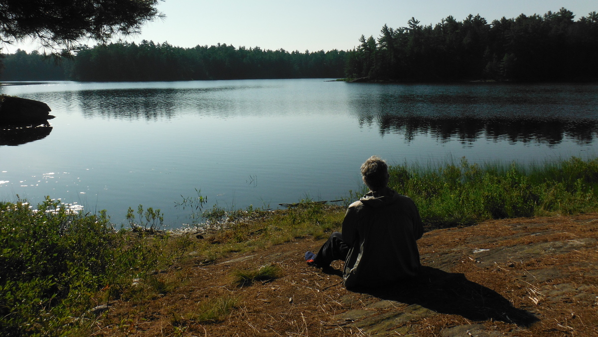
 |
| Pic.26. One day we'll come back here. |