Friday, August 20, 2010

trip # 11 The Massasauga Provincial Park, Wednesday, August 18, 2010


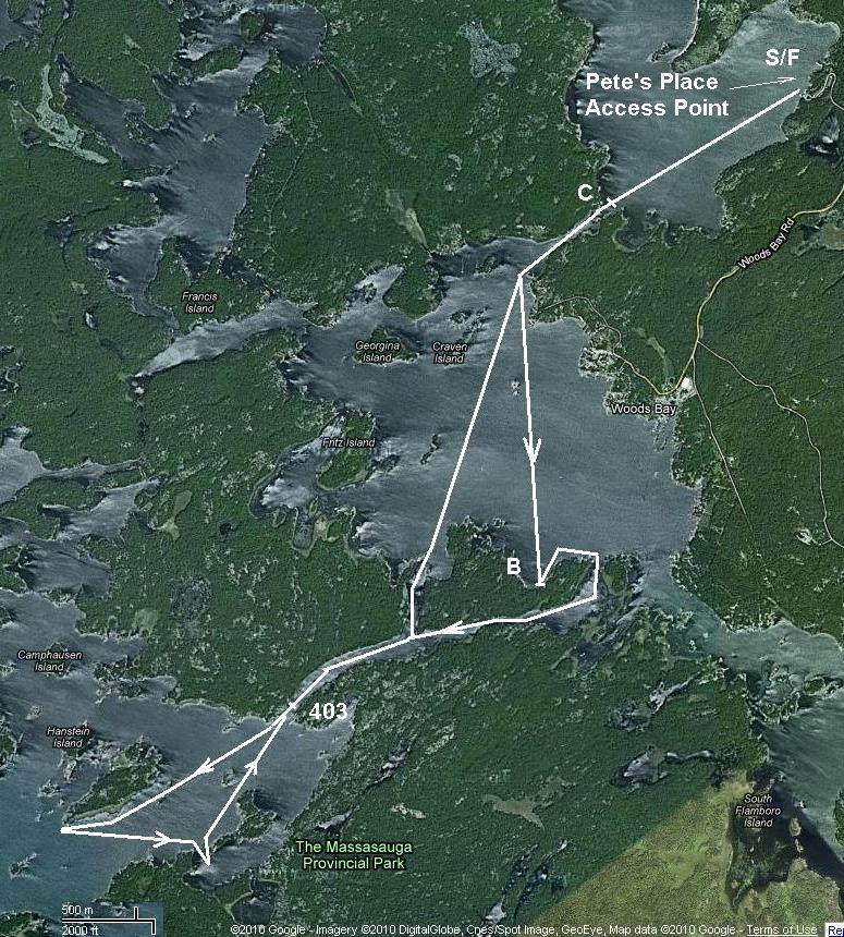
(Compare this map to maps from trips #5 and #6 of this year).

This time we left the house earlier and were on the water at 11:00. On our way to the Woods Bay (Moon Marina) we took Spadina< Lake Shore Blv, Parkside, Weston Rd, Black Creek, hwy 400 North, hwy 69 (exit 189 from 400), Muskoka Rd 11, Healey Lake Rd. We visited shortly Pete's Place Access Point to the Park to buy new map of the park with the camp sites and to learn that they still cannot provide parking for the day users (mentioned some kind of contract between Park and marinas).


From the Moon Marina ($8:00 for one day parking) we navigate to the Eastern entrance of the Captain Allan's Strait and along it to the Western shore of the Moon Island. Then NW along the shore and between small private islands to the seclude inlets with the sites 307 to 313. We checked 307 and camped on 309. 308 slightly to North was occupied.


Spent wonderful time swimming and fishing (me) and answering phone calls and sleeping (Irina). Plus prepared dinner (minestrone soup and tea).


At 6:00 PM we left for way back. Thought to try the sail, but wind died fully and sail was broken again (it's second time! and I decided to return it forever and forget about this sail). It bekame a tradition already to swim in the Captain Allan's strait (at site 403) on our way back.


10 past 8:00 we landed at the Moon Marina and at 8:40 left for home.
Were at home on Front St. at about 11:30 PM.

Very nice day!

Thursday, August 12, 2010

trip # 10 Beausoleil Island again, Tuesday, August 09, 2010

After a long delay due to our moving to the new place in downtown Toronto we finally escape to the Georgian Bay again. Longer trip time from downtown forced us to choose closer destination and we drove to the Beausoleil Island (Exit 156 from hwy 400 and then 32 km on the hwy 5 to the Honey Harbor).
The same pier in downtown Honey Harbor near the Church and Library, the same parking at Joe's backyard for $10 per day. Bought a snake at the local store and leave the marina at 2:10 PM. "Better later than never."

Went through Big Dog Channel and then turn right (North) along the shore of the Beausoleil Island.  Made two stops: first one very short - to swim, and the second one - in a small bay with the fire and snorkeling.


Кипяток для мису-супа и другая кастрюлька - для чая.


Опытный загребной Ирина Фурсенко. Техника гребка очень напоминает движения известной загребной Галины Н из Сиэттла.

More pictures in Picasa Album

Sunday, July 18, 2010

trip # 9 Crab Lake again, Friday, July 16, 2010

Again did we decide to visit Crab Lake dreaming of it's big basses and cozy island. One day trip with Vanya was exciting. He caught a few medium basses, fed a turtle at the campsite, while me sleeping after the lunch. Crowdy was the lake this Friday morning and much more Friday evening.

Monday, July 12, 2010

# 8: Massasauga Provincial Park, Sharpe Island, Wednesday, July 7

This time I brought Irina to see the beauty of the Georgian Bay. Initially I thought to go to the Crab Lake with Tanya. Then Tanya got more attractive offer and decided not to go with me.  Irina on the contrary all of a sudden decided to join me though strongly rejected Crab Lake idea as "annoying". Already in the car we changed our route from Bloomington East to King Rd West and 400. And we never regretted our decision. Two obstacles slightly slowed down our launch into Georgian: road construction between 69 and West Bay Marina and Marina itself. Previous times we parked at Peter's Place Access Point and had two launch pads and no troubles . At Marina we ended launching at the public launch and parking at Marina's (?) lot for $8.00. I still think that we could park free there. Otherwise the trip was beautiful.

Tuesday, June 22, 2010

# 7: Beausoleil Island, Monday, June 21

Three weeks without kayaking it's too much for me. This time I was going to go with my granddaughter Tanya a nice girl 20 years old coming to us for summer vacation from Siberia. I was thinking about something easy and not far from home to minimize driving time. It would be better on Georgian Bay because almost no mosquitoes there. I even began to consider Massasauga Provincial Park though i was there two last times. And all of a sudden friend of mine sent me report of his family trip near Beausoleil Island. The pictures were wonderful and circular trip drawing made by his 5 year old son attract me immediately. The weather forecast was very good for this Monday. Hwy 400 moved well, when we enter it from King Rd (exit 43) at 8:00 AM. At the Exit 156 we adopt a hwy 5 North toward the Honey Harbor and after 13 km stopped near the Church, Library and Public launch site. It was 9:15 AM. Of course everything equipped here for the motor-boats, not for the small inflatable kayaks. So we needed  some time to find proper place to inflate and launch our kayak and to park the car for a day (ended at nearby Joe's private parking lot for $10 per day).
At 10:30 AM we pushed off. The Park brochure we took free in the public box on the street contained the map of the Beausoleil Island. It was exactly the same map where little Tosha  drew his route.
Below is Google aerial view of  the Beausoleil Island and Honey Harbor with our South loop (white) and Tosha's North loop (yellow).
Leaving the harbor and having no idea where the Big Dog Channel is we decided to go South and reach the southernmost point of the Beausoleil Island, where the large group campsite has to be as was written in the books I read.
First we rounded small Picnic Island on our left (with the big gas station and store situated on the large wooden platform) then crossed the strait and went South along the East shore of the Roberts Island.


What we seen then was a huge open water space with the various colors of green on the horizon. Again we had no idea where the Beausoleil Island is. But having no choice and taking into account very good weather conditions (sunshine and light wind) I decided to paddle toward the light green cape in 3-4 km to South-West. And I was absolutely right! Less than in one hour we find out the pavilion among the trees and stepped down on the huge group camp site I read about. Long ago in 1819 Mister or Messier Beausoleil settled here as a first white man in this area. There we had a meal, took a picture of the turtles sunned themselves on the stones and Tanya as a "Girl with the paddle".

Our way back was to the North along the East coast of the Beausoleil Island.
More pictures at:My Picasa Albums

Monday, May 31, 2010

trip # 6 Overnight stay on the Wreck Island, Sunday May 30 - Monday May 31, 2010

My goal was as always - to reach the destination not reached previous time. Now it was Wreck Island in Massasauga Provincial Park (see trip #5 and the map with campsite descriptions). I decided to go overnight on Sunday to Monday to avoid the weekend traffic on 400 and to have a better choice of campsites.
Knowing that I'm not obliged to drive back tonight I was more relaxed when packing in the morning and left at 8:05 instead of 7:00. Highway 400 Northbound was not crowded and it takes me less than 2 hours to come to Pete's place Access Point in Massasauga Provincial Park.
The full time schedule of this trip is presented at the Russian version of this site.
The office was closed and I began the self-registration procedure. When I was almost ready, the officer came in and we switched to the regular procedure which I like more. Especially because we could discuss sites advantages and weather (wind first of all) forecast. As a result I choose site 336 on the Sharpe Island with the opportunity to switch to # 325 on Wreck Island if such will be my desire and it will be unoccupied. I paid $11.00 in cash (1 night for 1 person), received green sheet for the car parking and pink one for site occupation and dove to the launch point.
It takes me another 30 min to inflate the kayak and put everything inside.


11:05 AM I started setting my course to the first strait connecting Blackstone Harbor to the Woods Bay. In less than 20 min I was there and crossed the Woods Bay to the Captain Allen Strait.
(See map of the trip #5).
At 12:00 I made a stop at the site # 304 on the North bank of the Captain Allen Strait not far from where it flows into the Moon Bay (it's the point where map begins).
12:20 PM I headed toward the Sharpe Island. On my left were long island where we turned back last time with Ivan and then horseshoe shaped Pleasant Island.
#325 site inlet on the Wreck Island.Rocks are really impressive!

Inland part of inlet and fireplace at #325.

My tent on the smaller spot but closer to the fireplace.

Just before departure from Wreck Island.

Fantastic beach on the Northwest shore of the Sharpe Island.

Launch site at Pete's Place Access Point. My gear and my kayak.

End of trip.

Tuesday, May 25, 2010

trip # 5: First try of Georgian Bay, May 24, 2010

I've two choices for this long first summer weekend: Long Lake in Kawarthas or any place of my choice on Georgian Bay. Have to say that I never been to Georgian Bay kayaking though heard a lot about how fantastic it is. We were going duo: me and Ivan. Fishing which is very important for Ivan could be better in Kawarthas but the huge concentration of blood-sucking insects too. As to the Georgian Bay I have no special point chosen and weather (wind) conditions are more important there. So may be it was meteorologists who made final decision. They promised 27 C and almost no wind - ideal conditions for the Georgian Bay first trip. Then I spent a day reading the books and looking on the maps to find an optimal destination for the one day trip. It has to be closer to Toronto than Parry Sound and paddling distance no more than 20 km. Massasauga Provincial Park seems to meet all these requirements.
Again the first trip to new place turned out to be half as long as was planned initially (see map). We were lucky this morning driving on almost empty hwy 400 to the North. In two hours we were at the South Access Point (Pete's Place) to the Massasauga Provincial Park. (Exit 189 from hwy 400 to 69 (3.5 km), then Left to High Street (6,5 km) and then 17 km on the Healey Lake Road and 600 m right to the Pete's Place).
They confirmed that they provide parking only for their campers - others have to go to the various Woods Bay marinas. However when I bought the Park Map ($10:00) at the office they decided that it's enough to provide parking for us.
At 10:05 we put the paddles into water. Leaving the home at 7:35 it was great result!


45 minutes more and we are at the first strait connecting Blackstone Harbour to the Woods Bay.


Entering Woods Bay from East.


First short halt on the Southwest shore of the Woods Bay.

The geese took a rest too. At the farthermost point of our trip. From here we turned back.See map.

Nice beach at the site 403 on the strait between Woods Bay and Moon Bay. We swam here, had a lunch (misu-soup, sandwiches and vegetables) and relaxed before paddling back home.
We were back to the Pete's Place Access Point at 4:30 PM and at 5:00 PM started the car.
This time traffic was heavier than in the morning because it was the end of the long weekend. In spite of this in 2.5 hours we were at home.  Our first reconnaissance trip to Georgian Bay was fulfilled successfully.