
On the river everything depends on the water level. This time it was "medium" I think. Yes, it was spring but after such a snow-less winter no flood can be observed. And at any rate I'd like to come here in the midsummer. Even my inflatable kayak had to be lined or lifted over in too many shallow places. I think the current was stronger now than it will be in summer. As a result I lined the kayak in two places when going upstream, in sum it was may be about 1 km to splash through the cold water on slippery stones. Well enough that I have my beach-shoes with me and it was not so painful to step on the stones. In any case it was much better than on the portages, where both my hands were busy with the kayak and black flies and mosquitoes sting me cruelly.
And despite all this I had a wonderful time on Muskoka!

Launch site in Baysville at the small park on the West bank below the dam. Everything is ready to go.


Downstream the South Muskoka River

Fairy Falls about 2.5-3.0 km from the Starting Point in Baysville. Easy portage 155 m on the left bank.

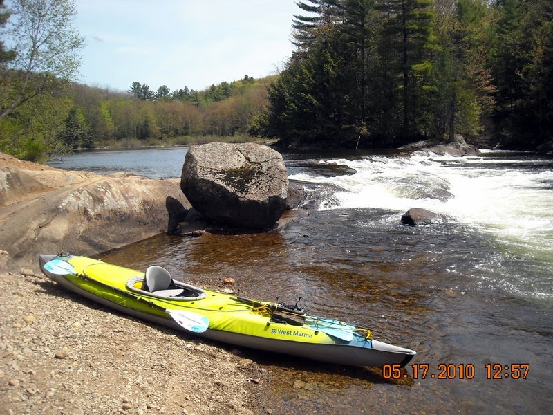
Approaching the rapids before the Thompson's Folly. On my way back I was forced to line my kayak upstream here for about 1 km.
My kayak already below the Thompson's Folly. I simply pulled it over the rock on the left.

Cooks Falls - the last I reached this time and the only one could try to go through on the kayak. I didn't try because didn't like to portage kayak back through the infuriate clouds of black flies and mosquitoes already biting me thoroughly.

Nice open spit upstream of a rapid - the only place I could rest a bit without be biting by the insects.

Typical Muskoka view, though the chairs are not 100% Muskokan.

Back to the dam and Start Point in Baysville after 5 hours paddling.

"Me and cucamber" - a self-made picture at the parking lot in Baysville. Finally I can eat a little bit without insect intervention.
Two more hours on the highways 117, 11 and 400 and I was at home!
Как я понимаю, это путешествие только планируется? Или уже произошло? В любом случае жду продолжения, фотографий, видео и подробных карт.
ReplyDeleteНет, путешествие уже БЫЛО - в понедельник 17 мая! Я только долго и по частям писал в блог.
ReplyDeleteПонятно! Ты что ли в одиночку такой вояж совершил? А как каяк перетаскивал? А вещи? А сборка-разборка? Фотки впечатляют!
ReplyDeleteЯ всегда пишу, когда я один, а когда вдвоем с ваней или с Ирой. В этот раз я был один. Никаких проблем дополнительных в общем-то не возникает. Каяк на то и Convertible, что может использоваьться и как двухместный и как одноместный.
ReplyDeleteТаскать я его уже наловчился на спине прямо в собранном виде. Пока самый длинный portage - волок был 155 м. Весит в сборе каяк около 22 кг. Вещей немного, все в непромокаемых мешках и если аккуратно все взять, то за вторую носку (после лодки) все уносится. Если лень все брать аккуратно и хочется иметь свободную руку, чтоб бить комаров. то два раза с вещами хожу.
ReplyDelete